You may recall I previously wrote about Which London Borough has the most tube stations? Well, as hinted at there, this is a direct sequel to that piece where I suggested there’s potential to look at all the TfL stations on the Tube Map, including the Elizabeth Line, Overground, DLR and Tramlink. I’ve decided not to include Thameslink as it’s not run by TfL, and if I were to do that, I’d probably have to add up all the national rail stations in each borough to see how many total rail stations are in each borough, but let’s not get carried away!
Adding up these stations is no easy task, as trying to work out which borough each stop is in without it being shown on the map requires some decent knowledge of London’s geography, specifically the borough boundaries. Any errors are mine and mine alone.
But before we get cracking, let’s remind us of what the other blog said as to the current picture of the London Underground stations. This does include the Northern Line Extension from 2021.
London Underground Stations by Borough
So Westminster and Brent have the highest amount of tube stations, with North Greenwich being the only one in its namesake. With the Elizabeth Line opening last year, there is now a new mode of transport on the tube map as it’s not technically a tube line (let’s not go there in this blog post!) But how do the stations that are within London’s borders break down by borough?
Elizabeth Line Stations by Borough
Ealing leads the way with 5 stations, followed by Hillingdon with four, although three of them are at Heathrow. Bexley gets its first station on the tube map with Abbey Wood being just inside its boundary.
But what about the London Overground? Given it’s mostly outside of central London, we’d expect to see a fair spread of stations but just how many stations are there in each of the boroughs? Well, I’ve totted them up using the old-fashioned method of perusing the map.
London Overground Stations by Borough
Unsurprisingly, there are the most stations in Hackney, with the North London Line and the East London Line extension meaning there’s a good number, making up for the lack of Underground stations. Brent is also surprisingly high, but this is because of its stations on the Watford-Euston line and the North London Line which give it that boost. Similarly, Waltham Forest has stations on the Gospel Oak-Barking Line plus the lines out of Liverpool Street.
Moving to the DLR, its concentration in East London means that there are far fewer boroughs in the table below. Many of you will rightly guess it’s a battle between Tower Hamlets and Newham as to which one has the most stations… Let’s find out!
DLR Stations by Borough
As you can see, Newham wins by three stations. Tower Hamlets would have easily won in the early days of the DLR but as the extensions moved eastwards in the 1990s and 2000s, Newham has climbed up to overtake its neighbour. In future, the DLR extension to Thamesmead would see another station for both Newham and Greenwich should the scheme be completed.
Finally, the Tramlink, no prizes for guessing that the majority of stops are in the borough of Croydon, but how many exactly?
Tramlink Stations by Borough
As expected, a comfortable lead for Croydon. The only proposed extension is to Sutton, which would also connect with South Wimbledon which sits in Merton. So if that scheme were to be built, the number of stations in Merton and Sutton would increase, particularly in Sutton where it would likely overtake Bromley into third place.
Now, this is where it gets complicated… Counting the various stations by mode is easy, but putting these together to work out which one has the most stations is tricky. For instance, Canning Town is both a tube and DLR stop, but on different platforms but within the same building, so do they really count as two stations? But head west slightly and Canary Wharf’s tube and DLR stops are definitely separate stations, and where does the Elizabeth Line (also a separate station) come into this? Gosh, this is getting out of hand!
So, for the sake of simplicity (I’m aware this might not make it accurate in some people’s eyes) I decided simply to add up these numbers from the various tables to see how many stops there are in each borough to give us some form of grand total. Drum roll, please…
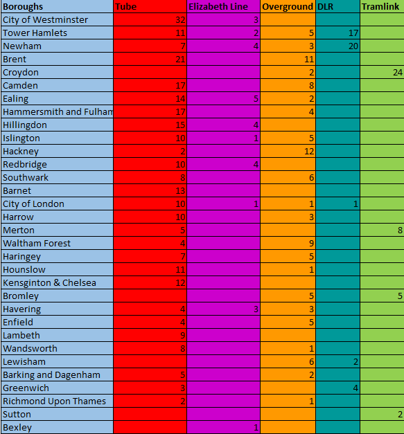
Total number of TfL stations by Borough
So Westminster and Tower Hamlets are joint top on 35 with Newham just behind on 34 and Brent on 31. What’s interesting is how most of Tower Hamlets and Newham’s stations come from the DLR, with a small boost from the Elizabeth Line. This would indicate that London Is Moving East, as someone famous once said!
Croydon’s position is inflated by the amount of Tramlink stations and to a lesser extent Hackney gets a much higher position because of the amount of Overground stations.
At the other end of the table, poor Bexley just sneaks on with one, but if the Elizabeth Line is extended further from Abbey Wood, they might get a few more stations to go its way. And as mentioned in my other piece Bromley would gain handsomely if the Bakerloo Line Extension were to proceed.
Sutton only has two at the minute but might move up the table as mentioned earlier thankfully Richmond has lots of national rail stations too, so don’t worry if you think there’s no way to get around in Richmond!
So there you have it, Westminster and Tower Hamlets are the London Boroughs with the most TfL stations on the Tube Map!
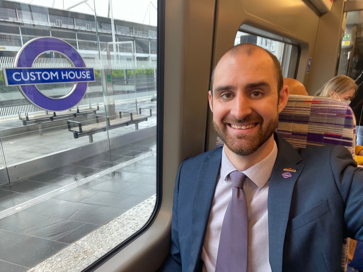
So I’ve just finished a long day at work, I’m stood on the platform at Custom House Elizabeth Line station in east London, it’s mid-November and there’s finally a chill in the air after an unseasonably mild autumn. A plane flies down behind the ExCel Centre as it lands at City Airport. I look up at the Dot Matrix Indicator on the platform and the first train is heading for Reading, the second goes to Heathrow and the third is terminating at Maidenhead…
It was then that it finally dawned on me that the Elizabeth Line is even more awesome than I first thought.
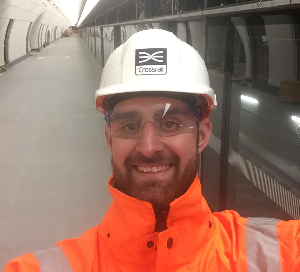
For full disclosure, this blog has been in the pipeline since just after the Elizabeth Line first opened back in May. Just before the big launch I did a blog on how excited I was to finally see it open, including how much it would add to London’s rail capacity, the size of the trains and the stations and why I believe it would be a gamechanger for our city.
It made sense to line up a sequel which would have talked about how great the new line is and indeed I did, but for the Young Fabians, which you can find here. In that blog, I briefly talked about the opening day but also why we should look to build Crossrail 2. But I wanted to write again for my own blog on this, so consider this Part 2. But I’m glad I waited until November to get round to finishing this… It’s now even better thanks to the eventual opening of Bond Street and then the through running which has only been in place for the last few weeks.
But let’s step back properly to those start of summer days of May 2022. I was up very early on that slightly rainy Tuesday morning to catch the first train from Paddington which departed at 6:30am with my good friends Sam and Marian. Bleary eyed and being slightly annoyed at having ripped a hole in my Elizabeth Line moquette socks (which had to go in the bin at the end of the day), I headed down on one of the last night buses to King’s Cross before jumping on one of the first Circle Line trains to get to Paddington. Already there was a sizable crowd with Sam already in the thick of it. Marian joined us shortly afterwards and you could really feel the buzz and anticipation in the air. After Andy Byford and Sadiq Khan met those at the front of the crowd, we were allowed down into the new station at Paddington and we awaited the first train. Finally climbing aboard, it felt like a new era had begun. My commute to City Hall in the Royal Docks just became much easier! We sped through to Abbey Wood in just under half an hour, the train packed with fellow enthusiasts. We returned back along the line to Farringdon for a spot of breakfast, then we sadly had to part ways and head off to our respective day jobs. When I arrived in the office, my colleagues were asking about it for most of the morning! It was a superb day and one that I will never forget. Certainly one to tell the grandkids when I get old that “I was on the first train!” (Which I’m sure they will be delighted by!) 😅
In the queue at Paddington.The end of the first train from Paddington!
I was also delighted to appear as the guest in YouTuber Geoff Marshall’s video for Custom House, Woolwich and Abbey Wood as he did a video at each station down the line. It was a really fun afternoon a couple of weeks after the line opened. If you still haven’t seen it, you can watch it here!
As I talked about previously, the size and design of the stations is one thing you can easily see when I was down there on site visits before they opened. But now they are there in all their glory for you to explore, without the building equipment and scaffolding in the way, you can really appreciate their brilliance. They look fantastic and really are a splendid addition to London’s rail infrastructure. A big railway project needed to impress and in my opinion it certainly does!
However, one aspect I could not anticipate on those site visits was the speed of the line. It’s quick… mega quick! You fly from one of London to the other in no time at all. That initial journey of just under 30 minutes doesn’t quite do it justice. You speed along as if you’re in a mainline train, at around 50-60mph but running safely through tunnels underneath the city. The journey between Whitechapel and Canary Wharf takes just 4 minutes, taking you from one end of Tower Hamlets to the other that quick is huge! Stratford to Paddington now takes 18 minutes, incredible! These journeys are transformational to our capital with the through running now in place and I hope people’s journeys are quicker as a result.
Additionally, the line is very well used. It has been busy on most days I’ve used the line, fellow commuters also enjoying the smooth and comfortable journey. Commuting on the line is a joy and it has made things a lot simpler, although I worked out that interchanging at Tottenham Court Road is quicker than going via Moorgate (a long foot tunnel at Moorgate and the fact the Bank branch of the Northern Line is also longer than the Charing Cross branch makes the difference). In the intervening months, you’ll be pleased to know the London Transport Museum also finally restocked the moquette socks and I was able to reacquire a pair!
The new Bond Street station on its opening day in October 2022.
But the Elizabeth Line has been a gift that has kept on giving as summer went away and turned into autumn. The opening of the delayed Bond Street station in late October gave us an extra treat as well as making things easier for those interchanging with the Jubilee Line in particular. The station is gorgeous too!
Then of course the switch to through running occurred in early November 2022. This is where the real benefit of the railway is felt and it felt a bit like another opening day. Without having to change at Paddington or Liverpool Street (instead the recommendation is to change at Whitechapel but this means staying on the platform rather than walking though the station) passengers really can harness the lines full potential. While the final stage to connect the Shenfield trains through to Reading is due in May 2023, the milestone a few weeks ago is one that I think will make the most difference.
So as I’m standing there in Custom House in east London, the night already drawn in, it’s crackers to think that one train can take me a far as Reading, although on this night I decide to head home to Archway and save the adventure for another time, as I mentioned, it has been a long day. The Elizabeth Line is awesome, truly. Its honestly a marvel of engineering and something that all Londoners should be proud of and you know, I’m not alone in think that…
Ok, July has been a super crazy busy month while I’ve been promoting my book, so this blog is very quick a “request blog” from my friend Nicki who asked a question of me yesterday that I don’t think has been answered elsewhere (correct me if I’m wrong!) and without sitting down to think about it, I couldn’t provide an answer. Which of Road, Street and Lane appears most on the tube map?
This sparked my curiosity enough to spend a small part of my Sunday evening doing some very basic additions to work out which of the following is the most popular. I broke this down into stations purely on the Tube Map, then I opened it out to include wider TfL services such as the DLR and the Overground before I finally included the Tramlink down in Croydon. I’ve put the result into a table below:
As you can see, Road appears most in all three categories, followed by Street before Lane brings up the rear (although there are more stations with Lane in their name on the trams than Street, which is interesting).
Sadly for you Avenue fans out there, there is only Warwick Avenue on the Bakerloo Line and the confusingly named “Avenue Road” on the trams that appear on the tube map with that word.
So there you have it, Road is more popular than Street in the names of stations across London!
So the time is upon us, after years of delays, London’s brand new train set, the Elizabeth Line (AKA Crossrail) will finally open on Tuesday 24th May. I’m hugely excited by this, so much so that I plan to get up early on the first day and make the first train that leaves Paddington station (which is at 6:33am). Most people won’t be too bothered by this. But for me, it will be worth it to say “I was there on the opening morning” to the grandkids. But what’s to get excited about?
The first thing you’ll notice is the sheer size of it. It will simply blow you away. It’s not a tube line like the others. These are mainline-sized trains running underground, which means the platforms are over 200m long, double the length of a standard tube train. The closest comparison is the RER in Paris, which sees mainline trains run through the centre of the city and connect up two suburban rail lines, which is exactly what the Elizabeth Line does. It will connect Abbey Wood in the South East and Shenfield in Essex through to Heathrow Airport and Reading in Berkshire going through tunnels in central London.
Me on the platform at Liverpool St Crossrail in June 2017 (before they installed the platform edge doors)
The stations have been rightly described as cathedrals. Having been down to see three of them in 2017 and 2018 (Bond Street, Tottenham Court Road and Liverpool Street), they are magnificent. They have been beautifully designed, with some excellent artwork. My personal favourites I’ve seen are the painted clouds on the roof of Paddington, the stencilled gold triangle design at Tottenham Court Road and the above station garden at Canary Wharf (which to be fair has been open for several years already). Plus they can handle not just the expected number of passengers at opening but also the future growth that is predicted over the coming decades. It really is state of the art and I think the passengers will have their socks blown off. I certainly did when I saw the progress being made when I visited.
Things will never be the same again (to quote Mel C). Journeys in London that previously took half an hour will now only take a matter of minutes. Parts of the capital will become much more accessible, especially on the southeastern branch with the Royal Docks and Woolwich being two of the best examples. Cross-city travel will be so much quicker. But because the trains are so long, you should probably pay a bit of attention to which end of the train you need to be at so you don’t lose some of that time benefit! And if you’re not familiar with London then apps like CityMapper will direct you to the best way to get around the city.
But it’s not just about speed either, Crossrail will add 10% to London’s rail capacity overnight, a huge leap. That extra space will make a huge difference to millions of journeys between the East and west. It will also greatly relieve the Central and Jubilee lines which will have a more pleasant journey as passengers transfer to the Elizabeth. So even if your route doesn’t take you directly on the new line, there will be fewer people on your current commute. Hopefully, for some of us, the days of cramped tube trains in the rush hour peak will be a thing of the past.
Me at Tottenham Court Road in June 2018, just before the delay was announced.
For me, it will also be great as I will be a regular commuter. My new office is in the Royal Docks and living in Archway, I will change at either Tottenham Court Road or Moorgate to get to Custom House. I’m hugely excited to be able to get to ride these trains each day and not just because my commute will be that bit quicker and easier. It’s a big moment in London’s history, whether you’re a train nerd like me or not, I think it’s something we should all share in. Certainly with the Northern Line Extension and the reopening of the Bank Branch, there have been some really exciting upgrades in the past year, but this will be on another scale. It really is a game-changer.
So I’ll see you on the rails, some of you bright and early at 6:30am and others in the coming days and weeks. But remember, wearing the correct moquette is always encouraged!
Get those crayons out! It’s another tube-based blog and this time I’m drawing unrealistic lines on the tube map to see what I think it could look like. Imagine this is Sandbox Mode where money isn’t a concern and we can build what we want and where we want. Given the current uncertainty around TfL’s finances, I hope to offer some escapism from all that so let’s see what I think we should do.
Extend the Bakerloo Line Admittedly this is actually on the agenda if TfL have the funds. The plan is to extend the line underneath the Old Kent Road where it continues to Lewisham via New Cross Gate. This would unlock thousands of homes and jobs. There is also a phase two planned where it would overtake the mainline to Hayes in Kent, giving Bromley a number of tube stations (as discussed in my blog Which London Borough has the most tube stations?) This will hopefully get a green light one day). Chance of happening: 7/10
Split the Northern Line after upgrading Camden Town I think this is also on TfL’s wish list. It makes logical sense given you can increase the number of trains if they don’t have to crossover at Camden Town. The southern obstacle has now been disentangled as Kennington was upgraded as part of the Northern Line Extension to Battersea. The plan is to upgrade Camden by giving it a new entrance where an old primary school currently is located. By building a new entrance and increasing the passageways and concourse, more passengers can change trains which would be necessary for example, High Barnet trains would only go to Morden via Bank and that would likely remain as the Northern Line and Edgware trains would go to Battersea and would need to be renamed (for what it’s worth, my favourite options are “Batterware” or “Edgesea” Line. There would also be step-free access created as a result. Hopefully, this will go ahead in the years to come. Chance of happening: 7/10
Extend the Metropolitan Line to Watford Junction As discussed in my piece TfL made a 2021 Tube Map in 2013. Let’s see what really happened, this was once on the drawing board but was removed when TfL rightly agreed not to fund any extra cash as the scheme was in Hertfordshire and the local council couldn’t increase the amount they’d agreed. It even got the legislative go-ahead and clearance works had begun when the scheme was cancelled. However, as it mostly runs along an old branch line, the provision is still there to extend to Watford Junction and link up with the Overground. Obviously, there’s a strong case that Londoners shouldn’t pay for a scheme that isn’t in there but it has the potential to bring more commuters from Zone 7/8/9 which is no bad thing. Chance of happening: 3/10
Extend the DLR to Thamesmead and Abbey Wood Also on TfL’s shopping list is to extend the DLR across the river to Thamesmead as part of the regeneration of the area, this would leave provision to extend it onto Abbey Wood to connect with Crossrail and greatly improve transfer links in the area. If TfL can find the funding, this would be a good project to invest in. Chance of Happening: 6/10
Extend the Gospel Oak-Barking Line further to Abbey Wood The GOBLIN (as it’s affectionately known) is currently being extended to the new Barking Riverside development with another station at Renwick Road also possible. This will deliver 10,000 homes to the area. But I believe they are making provision to extend the line across the Thames to Thamesmead and onto Abbey Wood. This would link up with Crossrail and give East London another river crossing. Chance of Happening: 5/10
The current GOBLIN extension to Barking Riverside.
Extend the Victoria Line Now we get into the more far-fetched ideas which are not that realistic, to be totally honest. However, this piece is totally for fun so you know what you signed up for! Anyway, the Victoria Line is the jewel in TfL’s crown. Running at up to 36 trains an hour in the peak, it can take you from Brixton to Walthamstow in just 30 minutes. What it if were to be extended? Where should it go? Well, I personally think it could be extended in both directions. First, southwards, it could go one stop to Herne Hill and bring it above ground. Once that is achieved, it would be possible to take over part of the suburban rail network and offer more travel options into the capital. Given the tangle of lines in south London, it would be a good chance to relieve pressure on Clapham Junction if people could go more directly into central. At the other end of the line, I would look to again bring it to surface level after Walthamstow and have it run on the Overground tracks to Chingford, where a limited number of Victoria Line trains would supplement the Overground in a similar way to the northern part of the Bakerloo Line. Pretty unrealistic as to maintain that kind of frequency over a longer distance, you need to purchase a good number of extra trains. Chance of Happening 1/10
Re-Open the Northern Heights The Northern Heights project was started in the late 1930s to extend both branches of the Northern Line and incorporate parts of the national rail network. The first phase was completed in 1941, which saw the line extended to Archway north via Highgate to take over the line to High Barnet and Mill Hill East (as it does today). However, the rest was never completed because of the war. It would have seen the line from Mill Hill East electrified further to Edgware, which also stopped at Mill Hill (The Hale) near to the Mill Hill Broadway station on the Midland Main Line. Then the LNER branch from Finsbury Park would have also been electrified and given to the Underground. This ran via Stroud Green and Crouch End to Highgate before continuing up to Muswell Hill and terminating at Alexandra Palace. Instead, the line was closed in 1953 and now forms the Parkland Walk where you can walk along the old line. There have been calls to reopen the line as the link would be handy for travel across North London, especially to Ally Pally. However, this is not going to happen, mainly because Parkland Walk is delightful plus there is a bat sanctuary in the old tunnel at Highgate and there’s a lot of legal protections for bat sanctuaries. Chance of Happening: 0/10
The Northern Heights scheme
Extend the Northern Line to Sutton Not as daft as it sounds, the current southern terminus of Morden could run past the depot and up onto the mainline tracks where it would run for another four stations before terminating at Sutton. It would certainly be a boost to the area although the problem with any southern extension to the Northern Line means the trains will already be full by the time they get to Tooting let alone Clapham, which would stop a scheme like this being viable. Chance of Happening 0/10
Extendthe Northern Line (again!) to Clapham Junction and beyond If Crossrail 2 (see below) were to ever get built, the now split Northern Line could be extended from its new terminus in Battersea to Clapham Junction. The reason why this isn’t an option currently is because the trains would fill up straight away at Clapham meaning no one would be able to get on before it reached Central. However, if Crossrail 2 were there, this extension would be handy. I then think there’s scope to take the line further over the existing mainline, either to take over the branches to Hampton Court or Chessington, which would free up capacity into Waterloo. However this is pushing it, isn’t it? Chance of Happening: 1/10
Extend the Waterloo and City Line and make it stop at Blackfriars Long talked about but never happened, the Waterloo & City is of course a handy shuttle to Bank. It runs directly underneath Blackfriars station, so a stop there would be handy for many reasons but building it must be a logistical nightmare. Plus the fact it was only handed over to the Underground in 1994, meaning for a long time it wasn’t even in their hands. But if it was to be extended, I personally would like to see it go up to Moorgate and take over the old Northern City Line to at least Finsbury Park or maybe if the Northern Heights were resurrected, it could take over that to Ally Pally. Southwards, it becomes tricky as the Northern Line and Bakerloo Line have that area covered. Even diverting it west it would get close to the Circle and District Lines which wouldn’t be feasible. So the poor W&C remains unextended. Chance of Happening: 0/10
Night Tube on more lines This is also in the pipeline. Currently, the Night Tube only runs on deep level lines such as the Central and Victoria lines (and hopefully will resume on the Northern, Piccadilly and Jubilee lines in the near future) but TfL has said they will look at running a Night Tube service on the sub-surface lines (those being the Circle, District, Hammersmith & City and Metropolitan lines) once the 4 Lines Modernisation programme completes an upgrade of the signalling of those lines. Would certainly be handy and would improve journeys at night for more parts of London if this were to happen. Chance of Happening: 6/10
Build a Crossrail station at Silvertown Although it’s not quite open yet at the time of writing, Crossrail in part runs along an old mainline at Silvertown in the Royal Docks. There was previously a station here which closed in 2006 and given its very close proximity to London City Airport, it would certainly be a handy stop. However, a feasibility study needs to be conducted to prove the business for opening a station, which the airport has said they would put up at least some of the cash for the scheme. Chance of Happening: 4/10
The current site of the old Silvertown station, now being used by Crossrail
Extend Crossrail Again, it’s not open yet, but there have been plans to extend Crossrail from is South Eastern terminus of Abbey Wood further to Gravesend or Ebbsfleet, where it would replace at least some of the current mainline services. We could also extend the line north after Paddington to run on the West Coast Mainline, which would improve transport links from Bedfordshire if you can get the train from either Tring or as far as Milton Keynes directly into central London. I’d say the extension from Abbey Wood has the best odds but this still is some way off. Chance of Happening 3/10
Reopen York Road on the Piccadilly Line A smaller scheme here, reopening the old York Road station just north of Kings Cross on the Piccadilly Line is another scheme which train folk wish would happen. The station building is still there, with the distinctive Leslie Green blood-red tiles and the station used to have lifts direct to platform level so there is hopefully the provision to have step-free access should the station reopen. Given the recent housing developments north of Kings Cross, more passengers would use the station, however reopening the station would disrupt the timetable for the whole line, so sadly this is a bit of a non-starter. Chance of Happening: 1/10
Open a Central Line station at Shoreditch High Street This one is also tricky for the reason above. Despite this, the Central Line runs directly below the Overground station so there is potential for a connection here, potentially when the Bishopsgate Goodsyard scheme gets built and if there’s a switch of passengers to Crossrail there might be scope to build this, although construction is also going to be tricky. Chance of Happening: 1/10
TfL take over more suburban lines to add to the Overground I would also devolve pretty much every suburban rail line to TfL. They have the ambition to take over the lines, many of which are south of the Thames. This could mean the “metroisation” of those lines which makes them more frequent in service and can improve services in the way the London Overground has been largely successful. This would undoubtedly make the Tube Map even more complicated but displaying those extra services on the tube map means more people end up using the service. While this is true for the Overground it will be interesting to see if Thameslink has an increase in passengers that could be traced back to its inclusion on the Tube Map since 2020. Anyway, TfL published a map of which services they would like to take over in 2016, which is roughly what I would do in my sandbox scenario. Chance of happening: 4/10
TfL’s plan to take over suburban rail lines from 2016.
Build the West London Orbital This scheme is also a long term ambition of TfL. It was mentioned in the Mayor’s Transport Strategy and would see an old freight line brought back into use. It would connect with West Hampstead and Hendon, down past Neasden (to connect with the Jubilee), Harlesden (to connect with the Bakerloo), Old Oak Common (for HS2 and Crossrail) before splitting off at South Acton to go to Hounslow via Brentford. The fact it would be a handy link and would bring an old line back into use makes this an attractive scheme to pursue. Chance of Happening: 6/10
The proposed West London Orbital scheme
Extend the Central Line to Uxbridge Like our southern extension of the Northern Line earlier, the Central Line tracks from its western depot run up to the Metropolitan and Piccadilly Lines just to the east of Ickenham station, this small connection would then give a third line on those tracks calling at Ickenham, Hillingdon and finally Uxbridge. However as the area is already well served, it’s unlikely to ever happen plus the timetabling would be a nightmare. Chance of Happening: 1/10
Build Crossrail 2 Sadly currently mothballed, Crossrail 2 would run from South West to North East London and would be the biggest scheme on my map. The need for a connection from Chelsea to Hackney has long been discussed, with proposals dating from the 1970s for a “Chelney” Line which has since been superseded by Crossrail 2. The thing is when building a railway to support London’s future needs, it has to be this large, so another brand new “tube line” is unlikely to be built and instead, we need more Crossrail schemes to meet demand and relieve some of the pressure on other lines, in this case the Northern and Victoria Lines. There is then potential for the line to run through further through Hackney and some of the old proposals see it take over part of the Central Line Loop. I also like how both Dalston stations would be merged into one mega station if this were to ever get built. Chance of Happening: 3/10
Step-Free Access everywhere Of course, I can’t have a blog like this and not include step-free access. I previously wrote about how Which Tube Line Is The Least Accessible? but in my sandbox scenario, this wouldn’t be an issue, every station would have step-free access to help everyone get around the city. However, the reality is would cost a lot of money and would be difficult logistically in many central London stations. Chance of Happening: 0/10
So that’s what I would do if I could. How would you change the Tube Map? Let me know!
Following on from my previous tube blog on how many stations are in each London borough, I’ve gone on to to wonder how many times the name of each London’s 32 boroughs appears on the tube map (which as far I can can tell, no one has ever written about because frankly it’s incredible niche but I know there’s plenty of people out there who will be interested to find out the answer).
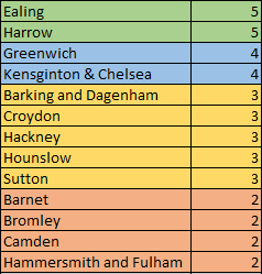
So, here we go. Let’s start with just the 272 London Underground stations on the January 2022 tube map shall we?
How many times each borough appears in the name of a tube station
As you can see, Harrow tops the table with five mentions (Harrow on the Hill, North Harrow, South Harrow, West Harrow and Harrow & Wealdstone). Both Ealing and Kensington & Chelsea have four mentions although I admit they are all Kensingtons. You should consider Barking & Dagenham and Hammersmith & Fulham to be lucky as they have both parts of their borough names mentioned in tube stops and are therefore at an advantage in this table. The only other borough to have multiple mentions in tube stations is Hounslow with three stations on the Piccadilly Line.
This leaves twelve boroughs who have one station bearing their name. This can seem strange to some as places like Redbridge and Southwark are more “somewhere in the borough” as opposed to what we would consider the geographic centre like Westminster or Camden. Brent does appear on the tube map, however it’s in the name of Brent Cross station on the Northern Line, which is actually in Barnet. Plus the word Bromley appears in the name of Bromley-by-Bow tube station, which of course is no where near the London Borough of Bromley… I also decided to omit the City of London from this for a similar reason that London Bridge station is not in the Square Mile (plus it’s not a London Borough anyway…). Who says these things are complicated?
The remaining fifteen boroughs don’t have their name feature in a tube station. But what happens when you open it up to all the stations on the tube map? Adding in the Overground, DLR, TfL Rail and now Thameslink means a massive expansion in the number of stations to consider. But how would that affect the table? Let’s find out…
And how many times their names appear on the whole tube map
With all the stations on the tube map now included, Ealing draws level with Harrow thanks to West Ealing on TfL Rail. Surprisingly, Greenwich jumps up to four mentions, with two on the DLR and one on the cable car, plus North Greenwich on the Jubilee Line.
Similarly, Croydon, Hackney and Sutton all jump up from zero to three. Hackney is mentioned in three Overground Stations and Sutton in the names of three Thameslink stations. Croydon is a mix of Overground, Trams and Thameslink.
Three boroughs also move from one to two mentions. Camden Road on the Overground, New Barnet on Thameslink and Bromley South again on Thameslink (and this time actually in the borough of Bromley) mean they join Hammersmith & Fulham on two.
Five boroughs names are mentioned elsewhere on the tube map but not in the name of a London Underground station. These being Haringey (Harringay Green Lanes and yes I’m ignoring the different spelling), Wandsworth (Wandsworth Road Overground), Lewisham (which is the end of a branch of the DLR), Enfield (because of Enfield Town Overground) and Merton (because of South Merton on Thameslink).
Unfortunately for Bexley, Havering, Kingston, Newham, Tower Hamlets and Waltham Forest, their names do not appear on the tube map at all. Some like Havering, Newham and Tower Hamlets were only created by the London Government Act of 1963, by which point most of the tube map was built in one form or another so they’re too new to have station named after them. Kingston and Bexley DO have train stations, but they’re not on the tube map as these are served by mainline services but not Thameslink. Finally, Waltham Forest is unlucky because of the two Walthamstow stations but given that they’re not the name of the borough, they don’t fit the bill. Again for you City of London fans out there, I’m sorry to disappoint that I didn’t include City Thameslink, while this might be classed as a mention for its name on the tube map, I refer to my earlier point of the fact it isn’t a London borough!
So there you have it, how many times a London Borough’s name appears on the tube map! Given that Harrow and Ealing are both on there five times, I wonder if there’s a tube challenge of sorts in there…
Also, if you enjoyed this, then check out my other tube pieces below:
With the opening of the Northern Line Extension last month, it got me wondering which borough has the most tube stations. There was already a news article on this subject but I thought I’d update the situation before looking ahead to see how it could change in future if some of the proposed extensions to the tube ever went ahead.
So with the NLE opening, we see the addition of Nine Elms in Lambeth, bringing their total up to 9 and Battersea Power Station in Wandsworth taking them to 7, the current table looks like this:
The current picture
I should also point out that I’m just doing London Underground stations. If we were to add DLR in then east London boroughs such as Newham would be much higher. Plus the Overground and Crossrail would also lead to a greater spread and of course, there are many, many mainline stations across all the London boroughs, so the city is well served by the various forms of railways. Maybe that’s a blog post for another time?
No surprise that Westminster and Camden are at the top of the list. Being so central and having so many tube lines run through them. What’s more surprising is Brent and Hammersmith being so high up but this reflects the fact that the tube was initially built for commuters from the west of the city rather than their poorer counterparts in the East End. Similarly with Ealing, Hillingdon and Hounslow have multiple tube lines despite being so west.
At the other end of the table, North Greenwich provides the only tube stop for its namesake and Hackney just sneaks on by having Old Street on its boundary with Islington and Manor House on the border with Haringey. Plus Richmond has its namesake and Kew Gardens to give its two stations.
Five boroughs have never had a tube station, these being Bexley, Bromley, Croydon, Kingston Upon Thames and Sutton. It’s also worth noting that Lewisham previously had two but when the East London Line became part of the Overground, they transferred over and were no longer classed as part of the tube network.
And some tube stations aren’t even in London so don’t make this table. The eastern end of the Central Line stretches into Essex and the end of the Metropolitan Line pushes into Hertfordshire and on into Buckinghamshire.
So how could the picture change in future if some proposed tube extensions get the green light?
If phase one of the Bakerloo Line extension were to proceed, Southwark would get two more stations at Burgess Park and Old Kent Road respectively and Lewisham would come back onto the grid with stops at New Cross Gate and Lewisham.
However, the potential for phase two of the Bakerloo Line would bring about bigger changes. The transfer of the Hayes Line to the Underground would see 10 more stations added to the tube map. Lewisham would gain three more stations, taking it to five and Bromley would gain 7 stations and shoot up into mid-table. As such the table could possibly look like this in future:
The potential future picture
The only other extension to the Underground specifically would be to continue the new Northern Line Extensions for one stop to Clapham Junction, adding another one to Wandsworth’s total. However, this won’t happen anytime soon though because the sheer volume of passengers jumping on the tube would overcrowd it from the get-go. Only if/when Crossrail 2 is built would there be the ability to build that link without overwhelming the Northern Line.
In the past decade, there were plans to extend the Metropolitan Line to Watford Junction, however, these stations would have all been outside of the Greater London boundary and the project was cancelled due to lack of funding, so even then they wouldn’t have been included on this table.
So there you have it, how the table of tube stations by borough might change in future.
Step Free Access (SFA) is vital for many Londoners to get around. However, until the last 30/40 years, this was not a consideration by those who built the tube. As such, many of its stations are difficult to navigate if you’re in a wheelchair, your carrying heavy luggage or you have a pushchair.
Since the inception of TfL back in the early 2000s, there has been a real effort to boost the number of stations that provide SFA. Those that did offer SFA got their own symbol on the tube map in 2006. This was then modified in 2011 to show two types, a blue blob now shows a station having SFA from the train to the street, whereas a white blob shows it from the street to the platform, but not the train.
However many stations are deep underground and not entirely in line with their surface station. Take my local stop of Archway, you take an escalator from street level away from the building to the tunnels below, meaning you can’t bore a lift shaft straight down to the platforms. This is the case for lots of stations, meaning SFA is sadly prohibitively expensive.
Furthermore, very few stations are actually at ground level. Obviously, the central London stations are all underground, whether they be “cut and cover” lines like the District or “deep level” lines like the Northern. However, when these lines eventually snake their way out of Zone 1, many of them travel on viaducts or their stations are above or below the tracks, meaning that accessibility is difficult to achieve.
Despite this, there have been huge strides made in getting as many step-free stations. Many on the outer edges of the lines may naturally be step-free, but they are also low-hanging fruit as often only a small lift is needed to deliver SFA.
It’s also worth pointing out that despite not being displayed on the tube map, both stations on the Waterloo & City Line are in fact step-free!
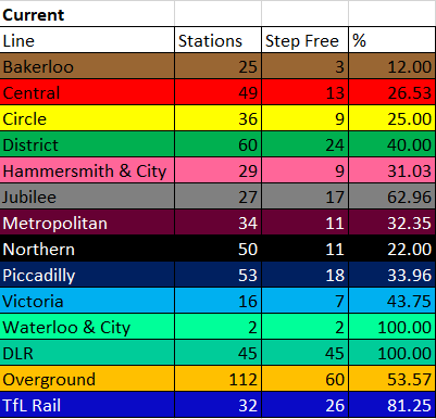
The current state of the lines and how many stations are step-free looks like this (including Ickenham which went step-free as I was writing this blog):
As you can see, some of the older, deep-level tube lines don’t have that much accessibility. But also it isn’t great for lines like the Met.
As the table shows the Bakerloo is in fact the least accessible, with only 12% of its stations currently offering SFA.
Contrast this with the DLR (first opened in 1987) which has all stations step-free, as does anything constructed since, so the Jubilee Line Extension in 1999 drastically boosted that percentage. Similarly, TfL Rail will shortly become the Elizabeth Line Crossrail. All stations on the new railway will be step-free, which has already given a boost to some stations such as Tottenham Court Road and very recently Ealing Broadway, in addition to the other stations which are soon to be complete, such as Moorgate and Whitechapel. Indeed it can be these major infrastructure projects that offer the chance to retrofit some stations and make them step-free.
TfL’s budget isn’t infinite but they’ve rightly focussed on major interchanges (for example Finsbury Park and Victoria have both gone step-free in recent years) as well as low-hanging fruit towards the end of the line (such as Cockfosters, Mill Hill East and Debden).
There are also several stations where works are underway, such as Harrow-on-the-Hill, Osterley, Sudbury Hill and Wimbledon Park which will mean more stations with the accessibility blobs shortly.
Other ongoing projects include the Northern Line Extension to Battersea which is due to open later in 2021. This will bring two new stations to the line, which will be step-free. This is in addition to the upgrade work at Bank station, which will bring SFA to the Northern Line platforms there too. Plus Knightsbridge on the Piccadilly Line is due to go step-free in the coming years.
So in future, taking all of the funded schemes into account, by my guess the table will look like this:
However, there are other schemes and opportunities which don’t currently have the funding, yet they might change this table even further. For example, I haven’t included Camden Town (Northern Line) or Elephant & Castle (Northern and Bakerloo) as those step-free schemes haven’t been confirmed yet. Also, there is an opportunity at Waterloo as Elizabeth House next door is scheduled for demolition and the Northern Line platforms sit right underneath. This provides a huge chance to make it step-free which won’t come around again for a long time. Similarly, there is talk of SFA being delivered at Walthamstow Central when the neighbouring shopping centre gets a refurb but this is not confirmed, along with a scheme for South Kensington on the Circle and District Lines.
There is also a number of deferred schemes as the funding isn’t available at present, This includes Snaresbrook, Hanger Lane, and Northolt which would be three more stations to the Central Line’s total. Burnt Oak on the Northern Line. Plus Boston Manor, North Ealing, Park Royal, and Ruislip for the Piccadilly. Ruislip is also on the Metropolitan which also has Rickmansworth on its deferred list.
Furthermore, if the Bakerloo Line Extension goes ahead, the four new stations there will be step-free, and if it takes over the Mid-Kent mainline to Hayes, then all of those will also have SFA.
With the unfunded schemes now added into the mix, this means the final table looks like this:
So maybe in 15-20 years time, the Bakerloo might not be bottom of this table. That crown will pass, just about, to the Circle Line, closely followed by the Northern, with the Bakerloo just above that. But until then, The Bakerloo remains bottom of the step-free league.
Huge thanks to Tomas from Step-Free London for his comments and his help in making sure I didn’t miss any of the numerous schemes that are ongoing or proposed!
Andy Burnham’s announcement this week that Greater Manchester would be taking back control of its bus service is significant. Here’s why.
Growing up in Wolverhampton, where the buses have been deregulated since the 1980s, has meant bus companies have run services purely for profit, with one operator effectively running a monopoly. This is true for many other parts of the country as a few large companies run the vast majority of services.
This has meant increasing prices, less frequent services and some routes being cut altogether which has accelerated a shift to cars for many people. This is backed up by the figures, which show that one billion fewer journeys are taken than in 1986 and in English cities journeys have declined by 53% excluding London. On top of this, funding for bus services has been cut by a third as part of the Tories’ austerity agenda since 2010. This combination has left parts of the country without a bus service.
When I went to university in Nottingham, I saw a vast improvement in the amount of services and I was impressed with a municipal bus company running a large number of them. NCT shows you what could be, with a well-run network of buses which have consistently won awards for the quality of their service. This should be the model which others try to emulate.
However, another problem with deregulation arose. The Derby Road is one of the main routes out of the city and it seemed to have a huge amount of buses running up and down, which was great, however, very similar routes were operated by different companies. This showed that they were competing over a profitable route (as you would imagine in an open market) but at what cost to other routes which are less profitable?
Upon moving to London, I was struck by how frequent, cheap and well-used the bus service was. This happens because the strategic responsibility rests with TfL. They set the routes, timetables and prices for how each route will operate. Companies then bid for which routes they want to run. Why is London different? Well, it’s because they were exempt from the deregulation in the 1980s, meaning the franchise model is still in place. Bus travel in London increased steadily over the past decade, although there has been a small dip in the last couple of years. But the increase can also be attributed to investment in bus lanes which ensure a speedy way to get around.
The other thing that struck me was the demographics of the passengers. Many buses are a snapshot of London, with a wide variety of people using them, not just the young and the elderly but commuters and families all using them as a way to get about. There is even a network of Night Buses, which is even more of an experience in the early hours of Sunday morning, trust me! But as well as carrying revellers after a night on the tiles, it also carries the hospital staff, cleaners and many other nocturnal workers who rely on a safe and cheap way to travel at all hours. This is key as it shows people are not automatically jumping in cars to get around. If there is a good enough bus service, people will use it, it’s as simple as that.
Contrast this to the past decade elsewhere in the country. The bus fares have continued to rise, and those less profitable routes have been cut, meaning villages have effectively been isolated if services have been reduced dramatically. Indeed many councils have cut their bus subsidies completely, leaving swathes of the country without a service at all. This cuts communities off and limits the opportunities of people in those areas, as well as increasing car use. In turn, this creates more congestion as well as increasing air pollution.
Andy Burnham’s announcement this week makes Manchester the first authority to take up the devolution on offer in the Bus Services Act 2017. This was championed by former Chancellor George Osborne and allowed combined authorities to franchise their bus services, similar to London. A strange reversal of the Thatcherite policy, but it shows you that Osborne cared about devolution more on this occasion. However, the act does not allow them to create their own bus companies, similar to NCT in Nottingham. This is a huge missed opportunity to allow the public sector to run a service for the benefit of its people, not for private profit.
The benefit of having the local authority control the routes is that less profitable services are able to operate as they are subsidised. So your small bus that runs around an estate might not make you much money but is vital for ensuring people, especially the elderly, can get to the shops. Increasing services and reducing fares will help bring passengers back on the buses, which in turn means fewer people using their cars and might even be healthier if you have to walk to the bus stop.
This is why this week’s announcement is crucial. By bringing the buses back into the public sector, we remove the competition element, which will mean we can reduce fares and implement a set of routes that ensure good coverage and good frequencies. This will hopefully reverse the downward trend our buses outside London have been on since the 1980s. Liverpool and the North East combined authorities are also looking at this. I hope it’s the start of a revolution in how buses in this country are operated so that once again they are run for the benefit of the local community and not the profits of private companies.
One of the things that TfL likes to do periodically is release what the tube map will look like in several years based on their plans going forward. I recently found one on my PC for the year 2021 which was published in November 2013. So, let’s dive into this map and compare it to where we actually ended up.
Crossrail/Elizabeth Line
As you’d expect, the 2013 map predicted an open and functioning Crossrail running through London. Instead, we’ve got two bits of TfL Rail on either end of Zone 1. Interestingly the map makers decided to show all of the stops on TfL Rail, rather than the “To Maidenhead” and “To Shenfield” that is shown on the 2013 map. They even put them in “Outside Fare Zones” which makes sense but the colour isn’t that distinctive when looking at the paper map. Also note that Crossrail is a different colour to the Elizabeth Line’s updated shade of purple and it terminates at Maidenhead before it was agreed to run services further to Reading.
While I have no doubt that Crossrail will be excellent and will revolutionise travel across the capital when it finally opens, its omission from the current maps is stark as it runs right through central London. It will be a firm fixture in the 21st century and I can’t wait for it to open.
Metropolitan Line Extension
How the Met Line Extension would have looked (Image from TfL)
The other big omission is the Metropolitan Line Extension (MLE) also known as the Croxley Rail Link. This would have seen the Watford branch split off after Croxley, run along an old branch line to link up with the Overground at Watford High Street before terminating at Watford Junction. It would have improved access to Watford Football Club and the local hospital. The scheme was championed by former mayor Boris Johnson (anyone know what he’s up to these days?) who pretty much allowed a blank cheque to finish the route. But in 2016 the project ran into the old issue of “spiralling costs” leading to the then-new mayor Sadiq Khan shelving the MLE, raising the point that TfL alone would have to cover these spiralling costs.
I personally really liked this scheme and they even did the prep work before it got mothballed. Recently a local councillor in the area called for the Department for Transport to fund the scheme as it is a “shovel-ready” project which could help with the economic recovery. The only issue with that is that the permission to build the line has expired, so it would need approval and a lot of funding to get this scheme going again.
Northern Line Extension
The Northern Line Extension (Image from TfL)
However, one extension which is very much due to open this year is the Northern Line Extension (NLE) to Battersea. This was funded using developer contributions for the massive housing development that has been under construction around the power station for the past few years. The first test trains ran down there over Christmas 2020, giving us train nerds something to get excited about in 2021. It will be the first extension of the tube since the Piccadilly extended to Heathrow Terminal 5 in the late noughties and will bring the number of tube stations on the map to 272. There is also a provision to extend the line to Clapham Junction should Crossrail 2 be picked up again.
Overground
The map also pointed out TfL would be taking over the suburban metro routes out of Liverpool Street, which they did in 2015. This added a lot of stations in NE London to the map, making it slightly cluttered but nonetheless necessary. Having these stations on the map does actually work in boosting passenger numbers. Rather than “build it and they will come” how about “display it and they will come?”
Step-Free Access
Other smaller differences are in the stations which have gone step-free. For example, big schemes like the one at Bank aren’t completed yet, while the one at Elephant & Castle is still yet to commence. Linked to this is Crossrail not opening fully, which will bring more step-free access to more stations (such as Moorgate, Paddington and Ealing Broadway) when it finally does open. So there are several access blobs on the 2013 map which aren’t true in 2021.
Some that were planned were complete, most notably at Finsbury Park. However, several stations which weren’t planned to be step-free actually are in reality. For instance, Cockfosters, Mill Hill East and Buckhurst Hill, to name a few, now are step-free but this wasn’t predicted in the 2013 map. This is because of TfL prioritising these stations since 2016. Most of these are not underground so mostly it’s a small lift needed to get the step-free access.
Thameslink
Just some of the extra stations now on the map following the inclusion of Thameslink (Image from TfL)
Despite all the predictions in the 2013 map, there is one huge change which came about in the December 2020 map which few would have predicted back then. After pressure from the London Assembly, Thameslink services were put back onto the map as a temporary measure during the COVID-19 Pandemic. They used to be present in the 1990s but ran only through the core from Kentish Town to Elephant & Castle. When TfL came into existence in the early 2000s, the service disappeared. However, TfL has brought it back, and not just the central section, but all Thameslink served stations within the tube map zones. This adds a huge number of stations, especially in south London. Because of this, it could be argued that this is the first tube map in history to acknowledge that south London exists.
Walking Interchanges
TfL also decided to include “walking interchanges” on the December 2018 map. This showed a dotted line between two stations that are less than a ten-minute walk from each other. Again this is a sensible addition as it might encourage people to walk between those stations.
Riverboat Services
Another smaller change that wasn’t predicted was the inclusion of blobs for the Thames Clippers. They were added to the map in December 2019, again “display it and they will come” springs to mind. They’ve been announcing the riverboat interchanges on the tubes for a lot longer, so it only makes sense to add them onto the map, especially if the paper tube maps are being used mainly by tourists these days
So there you have it, not all of TfL’s predictions came true, the tube map is undoubtedly a working document and there will also be innovations such as the walking interchanges that can alter its appearance. However, some changes like delayed or cancelled projects do make these exercises interesting to look back on. I’ll be back in 2040 to dissect the 2018 prediction of what the tube map will look like then, but until then stay safe!